Question 1 of 10
The term 'ENCLAVE' in political geography refers to:
AA city that has no relationship to any state.
BA concept with no geographic significance.
CA state that has no borders with any other state.
DA portion of one state's territory that is completely surrounded by another state's territory.
Explanation
An ENCLAVE is a portion of one state's territory that is completely surrounded by another state's territory. Kaliningrad (Russia, surrounded by Poland and Lithuania) and Lesotho (surrounded by South Africa) are commonly-cited examples. An EXCLAVE is a related concept — a portion of a state's territory separated from the main body of the state.
Question 2 of 10
The Strait of HORMUZ is strategically important because: 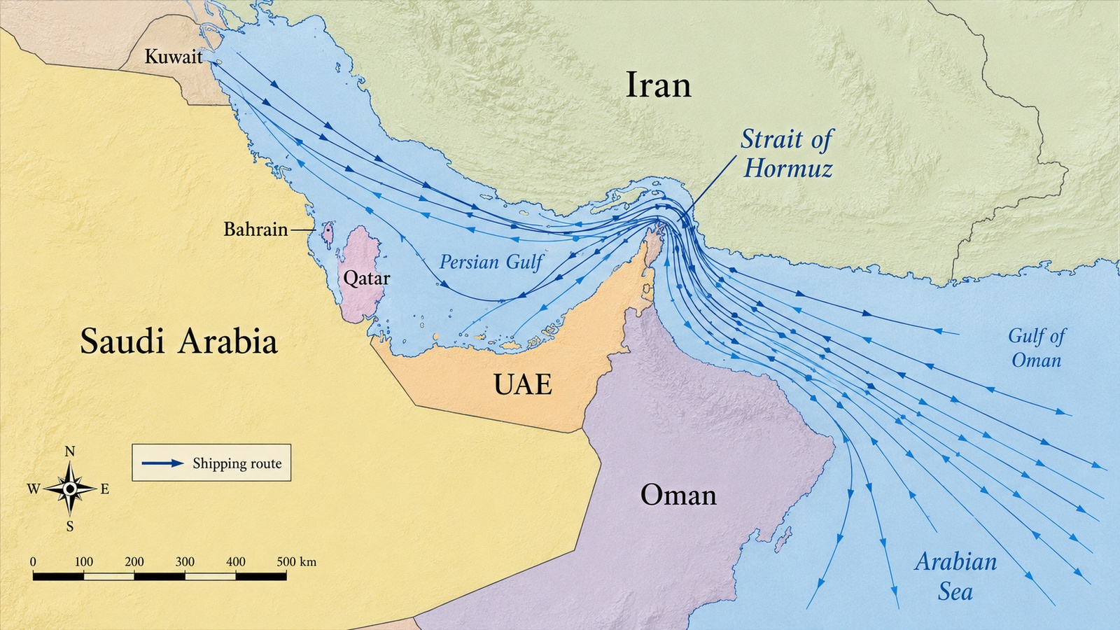
AIt is the widest strait in the world.
BIt has no economic or geopolitical significance.
CA substantial share of the world's seaborne petroleum passes through it.
DIt connects the Baltic Sea to the North Sea.
Explanation
The Strait of HORMUZ, between the Persian Gulf and the Gulf of Oman, is strategically important because a substantial share of the world's seaborne petroleum — from Persian Gulf producers — passes through it. Its width, location, and traffic volume have made it a persistent geopolitical focus.
Question 3 of 10
Which of the following BEST describes a MOUNTAIN?
AA depression in the ground filled with saltwater.
BA large natural elevation of Earth's surface rising abruptly and to a substantial height above its surroundings.
CA moving mass of air at the surface.
DA wide flat area near sea level with no relief.
Explanation
A mountain is a large natural elevation of Earth's surface that rises abruptly and to a substantial height above its surroundings. Options B–D describe other kinds of geographic features.
Question 4 of 10
The climograph shown displays monthly temperature and precipitation for a South Asian city. Temperatures are warm year-round (25–35°C), and precipitation is heavily concentrated in June–September (heavy monsoon rains) with a dry season in October–May. Which climate type does this pattern MOST closely match?
APolar tundra climate with year-round subfreezing temperatures.
BTropical monsoon climate — warm temperatures year-round with a strongly seasonal wet–dry precipitation pattern driven by the South Asian monsoon.
CContinental interior climate with hot summers and very cold winters.
DMediterranean climate with mild wet winters and dry summers.
Explanation
TROPICAL MONSOON CLIMATE is characterized by warm temperatures year-round and a strongly seasonal wet–dry precipitation pattern driven by the seasonal reversal of prevailing winds. The South Asian monsoon produces this pattern across much of India, Bangladesh, and Southeast Asia. Options B–D describe unrelated climate types.
Question 5 of 10
The ARAL SEA — historically one of the world's largest inland lakes, located in Central Asia between Kazakhstan and Uzbekistan — has shrunk dramatically since the mid-20th century. The primary cause was: 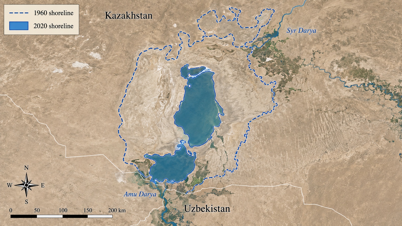
AAn earthquake that permanently drained the lake bed.
BA meteorite impact that removed most of the water.
CA single volcanic eruption that vaporized the lake water.
DDiversion of the two rivers feeding the sea (Amu Darya and Syr Darya) to irrigate cotton and other crops in the surrounding Soviet and later independent republics.
Explanation
The dramatic shrinkage of the ARAL SEA — losing more than 90% of its original volume between 1960 and 2010 — was primarily caused by Soviet-era diversion of the Amu Darya and Syr Darya rivers to irrigate cotton and other crops in the surrounding republics. The environmental, health, and economic consequences to the region have been severe and widely-studied.
Question 6 of 10
The Aswan High Dam, completed in 1970 on the Nile River in Egypt, is one of the 20th century's largest engineering projects. It transformed both the physical and the human geography of the Nile Valley. Which of the following BEST describes intended effects of the dam? 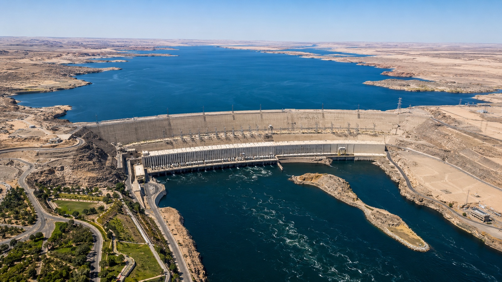
AIt eliminated the Nile River entirely and replaced its channel with a paved highway.
BIt reversed the Nile's flow direction, causing the river to run southward toward the equator instead of northward.
CIt ended all human settlement along the Nile Valley immediately after construction was completed.
DIt allowed year-round agricultural irrigation, generated large-scale hydroelectric power, and created one of the world's largest artificial reservoirs (Lake Nasser) upstream of the dam.
Explanation
The Aswan High Dam was designed and built for three main intended purposes: (1) controlled year-round irrigation of agricultural land in the Nile Valley (replacing the pre-dam pattern of annual seasonal flooding), (2) large-scale hydroelectric power generation, and (3) creation of Lake Nasser — one of the world's largest artificial reservoirs — behind the dam. Options B–D describe effects that did not occur; the Nile still flows northward to the Mediterranean, and settlement along the valley continues today.
Question 7 of 10
Which of the following BEST describes the term 'climate'?
AThe specific weather on a single day at a specific location.
BThe exact temperature at a location at a specific hour.
CThe long-term average pattern of weather at a location (temperature, precipitation, wind) over many years.
DA one-time weather event such as a single thunderstorm.
Explanation
CLIMATE is the long-term average pattern of weather at a location (temperature, precipitation, wind patterns) computed over many years. Weather (option B, C, D) refers to short-term atmospheric conditions.
Question 8 of 10
The Great Barrier Reef off the northeastern coast of Australia is the world's largest coral reef system. Which set of physical conditions is MOST important for supporting reef-building corals? 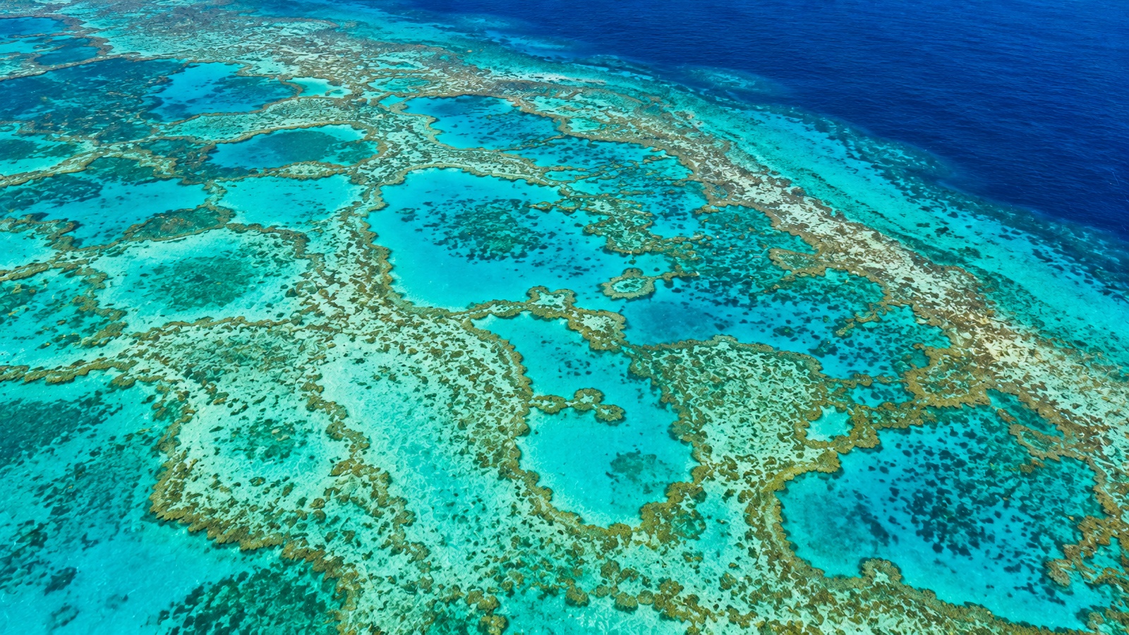
AFresh (non-saline) inland lake water at high altitude.
BCold, dark, deep, low-oxygen seawater with no sunlight of any kind.
CAny body of water regardless of temperature, depth, salinity, or clarity.
DWarm, clear, shallow, well-oxygenated seawater with sufficient sunlight for the symbiotic algae inside coral tissues to photosynthesize.
Explanation
Reef-building corals host symbiotic algae (zooxanthellae) inside their tissues, and those algae photosynthesize. That combination means reef-building corals are restricted to warm, clear, shallow, well-oxygenated seawater — where sunlight can reach the algae. The Great Barrier Reef sits in exactly this physical setting. Options B–D contradict the ecological requirements of reef-building corals.
Question 9 of 10
The concept of a FRAGILE (or FAILING) STATE in political geography is BEST characterized by:
AA concept unrelated to any political-geographic analysis.
BA state with strong effective control and high government legitimacy.
CA phenomenon that has never been observed.
DA state whose government has limited effective control over its territory, weak provision of public services, contested legitimacy, and heightened vulnerability to internal conflict.
Explanation
A FRAGILE STATE is characterized by limited effective control over its territory (parts of territory not effectively governed), weak provision of public services (health, education, security, justice), contested legitimacy (populations question the government's authority), and heightened vulnerability to internal conflict. Indices such as the Fragile States Index attempt to measure these dimensions. Fragile-state geography is a major concern in development, humanitarian, and security policy.
Question 10 of 10
The population pyramid shown represents a high-income country with a narrower base than middle, a large working-age middle, and a substantial older-age top. Which of the following BEST describes this country's demographic profile?
AVery high fertility and high mortality at all ages.
BA population with no members over the age of 30.
CLow fertility, long life expectancy, and a growing old-age dependency ratio — the demographic profile of an aging high-income country.
DA population composed entirely of children under 15.
Explanation
A narrower base (low recent fertility), large working-age middle, and substantial older-age top are diagnostic of a HIGH-INCOME AGING COUNTRY: low fertility, long life expectancy, and a growing old-age dependency ratio (retirees relative to working-age). Options B–D describe shapes that do not match.