AP® World History: Modern U2
EasyImage
The map below shows major Afro-Eurasian trade circuits active c. 1200–1450. Based on the routes shown, which circuit connected West Africa to the Mediterranean world using an entirely overland route?
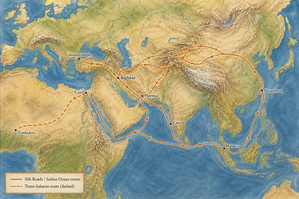
AThe Trans-Saharan route linking Timbuktu to Cairo
BThe Indian Ocean route linking Calicut to Malacca
CThe Silk Roads segment linking Constantinople to Baghdad
DThe maritime route linking Quanzhou to Hormuz
Explanation
The map marks the Timbuktu–Cairo link with a dashed line and labels it "Trans-Saharan (dashed)" — the only circuit on the map that runs entirely over land, crossing the Sahara to connect West African gold- and salt-producing regions to Mediterranean and Middle Eastern markets. The Silk Roads segment between Constantinople and Baghdad is also overland, but it does not connect West Africa. The Indian Ocean legs (Calicut–Malacca, Quanzhou–Hormuz) are maritime routes, shown as solid lines running through coastal port cities rather than across a desert interior.
More AP® World History: Modern practice
Image · U8
The map below shows Cold War alliance blocs alongside newly independent states in Africa and Asia, c. 1955. Based on...
Image · U6
The map below shows a simplified version of European colonial claims in Africa around 1914. According to the map,...
Word Problem · U9
The shipping container's significance for global trade, per this topic, was that it
Word Problem · U7
The Young Turks seized power in the Ottoman Empire in