AP® World History: Modern U8
EasyImage
The map below shows Cold War alliance blocs alongside newly independent states in Africa and Asia, c. 1955. Based on the map, which statement accurately describes the geographic relationship between the two Cold War blocs and the two regions of decolonization shown?
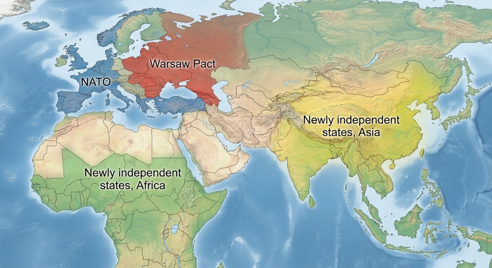
AThe two Cold War blocs and the two independent-state regions all sit in separate, non-bordering areas
BThe Warsaw Pact's territory in Europe directly borders the newly independent states of Africa
CNATO's territory in Europe extends directly into the newly independent states of Asia
DAll four labeled regions on the map physically overlap within the same area shown
Explanation
The map places NATO and the Warsaw Pact as two adjacent but distinct blocks in the upper portion (representing Cold War Europe), while the newly independent states of Africa and Asia appear as two separate, non-overlapping regions below and to the side. None of the four labeled areas touch or overlap another region on the map — the point the other choices get wrong. The map shows the Cold War alliance system and decolonization as geographically distinct processes happening in different parts of the world at the same time, not as bordering or merged territories.
Sẵn sàng bắt đầu luyện tập?
Free sample questions available. No credit card required.
More AP® World History: Modern practice
Image · U6
The map below shows a simplified version of European colonial claims in Africa around 1914. According to the map,...
Image · U2
The map below shows major Afro-Eurasian trade circuits active c. 1200–1450. Based on the routes shown, which circuit...
Word Problem · U9
The shipping container's significance for global trade, per this topic, was that it
Word Problem · U7
The Young Turks seized power in the Ottoman Empire in